
VITAL STATS
Name: Capulin
Type: Cinder Cone
Eruption Status: Extinct
Last Eruption: Approximately 60,000 years ago
Location: 36.7811° N, 103.9695° W
Northeastern New Mexico; Raton-Clayton Volcanic Field
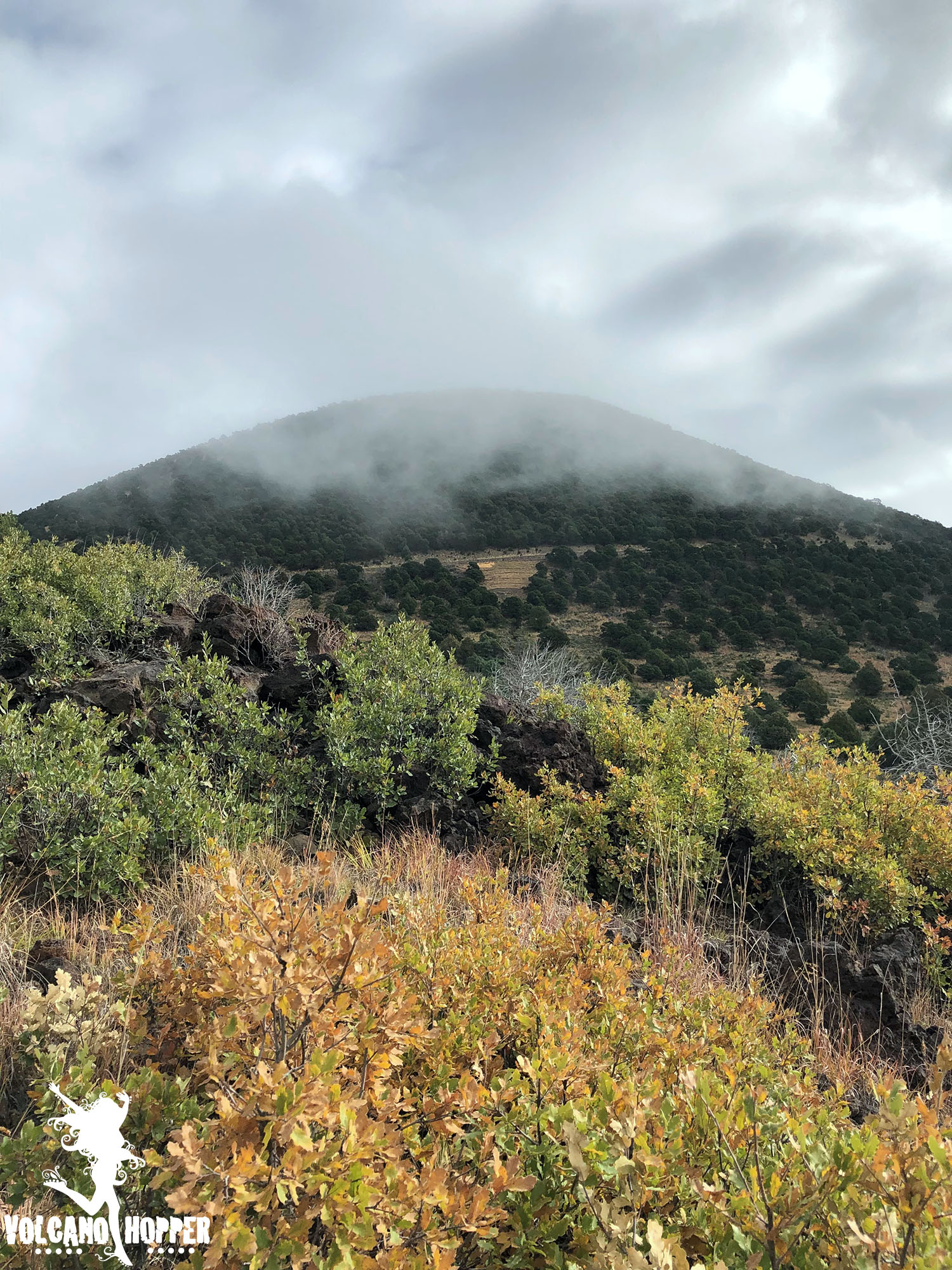
The clouds that enshrouded Capulin’s cone finally began to break around mid-morning. We raced to the summit to see what had been hidden behind the thick mist all morning. What we found was breathtaking.
Capulin’s summit crater is perched over 1,300 feet above the surrounding plains, and the drive to reach it is nothing short of intimidating. If you’re not driving, take a peek out the passenger side window. There are no guardrails and the view is straight down. This cone has virtually no slope. Not intimidating…not at all…
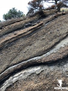
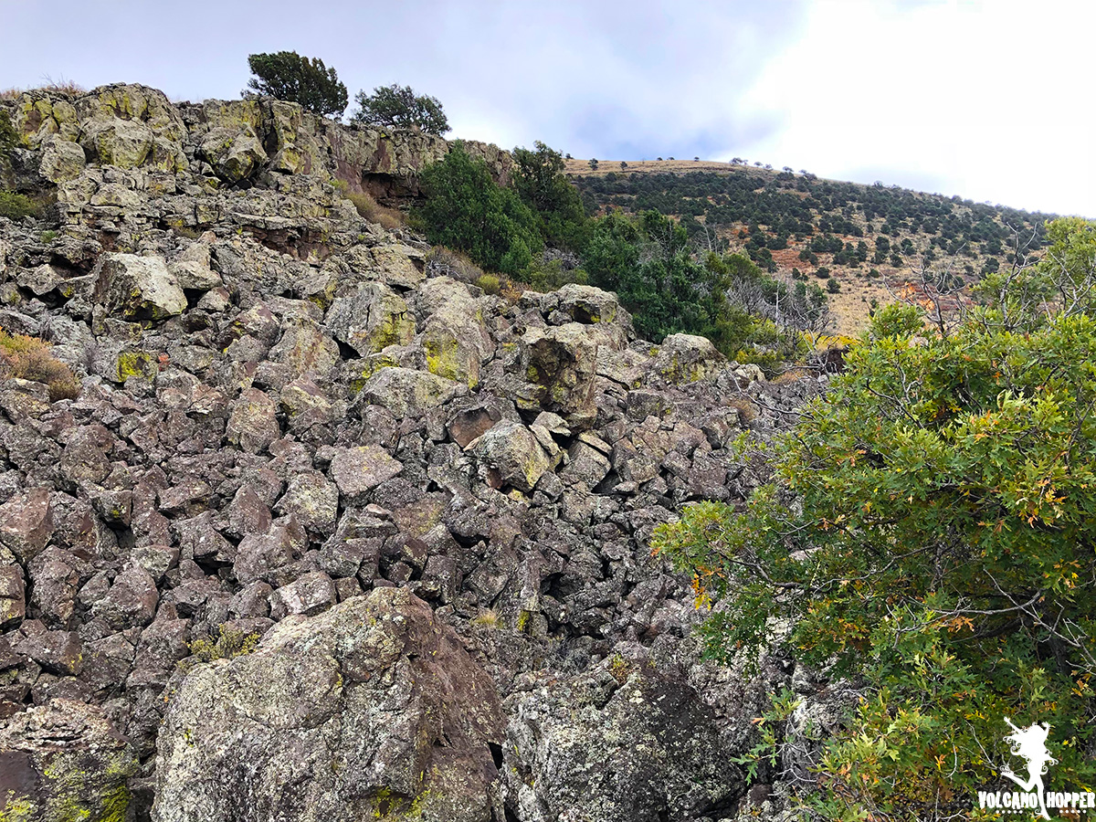
As you approach the summit, you can spot small cliffs of ash and cinder from the volcano’s last eruption. The materials are packed tightly together but, because of their composition, easily erode. Over the years the cinder and ash have weathered and oxidized (like an old car rusting in your driveway) and have changed to a warm reddish hue. You can still see the different layers of ash and cinder along these cliffs.
Capulin’s summit sits at 8,182 feet above sea level. To your right as you pull into the parking lot are spectacular views of the Raton-Clayton volcanic field. Old volcanoes pepper the landscape. And those massive mesas in the distance? They are massive lava flows that issued from the volcanic field thousands of years ago. You can still spot their dark color beneath the wash of trees and grasses.
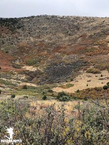
To your left (or rather – behind you – since you’ve gone running off to look at the views) is Capulin’s crater. It stretches like a gigantic bowl in front of you, the edges of its rims rising another thousand feet higher than where you stand. It’s like one of those Choose Your Own Adventurenovels that we read as kids: do you choose to walk the crater rim? Or do you choose to go down into the depths of the crater?
I couldn’t contain my excitement. I went bouncing like a billy goat down into the crater. (And this is why I’m called Volcano Hopper…)
Inside the Crater
The path to the bottom of Capulin’s crater is paved with asphalt. It’s an easy hike, but it is fairly steep with a 105 foot elevation drop. The trail was lined on both sides with bright orange scrub oak and red chokecherry shrubs. The Spanish word for “chokecherry” is Capulin. Spanish traders in the area gave the mountain its name because of these shrubs that used to grow all over the mountainside, giving off the sweet scent of roses. Nowadays, capulin (chokecherries) are mostly found in the summit crater. Other trees flood the crater with splashes of color for the oncoming autumn.
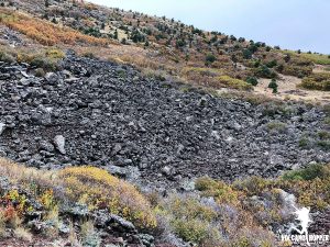
Suddenly, about halfway down, we burst from a cluster of scrub oak. The crater opened up in front of us. And, stretching across our path, is a massive lava flow. The basalt and cinder stretch up from the vent at the base of the crater. You can see the direction of the last blast of lava from the vent; one side of the crater wall is strewn with ballistic basalt.
The trail spirals further down into the crater past this massive streak of lava. It’s size is impressive in person: perhaps several football fields in length. There are several fissures in the rock that could easily hide a puma. We finally come to the end of the trail – right in front of the vent. The entire bottom of the bowl-shaped crater is coated in black lava. This is the spot where the last of the explosive ash and cinder was thrown from the volcano. This is the place where the eruption issued from; the place that built this entire mountain.
It’s eerily silent now. But once, extremely powerful forces were at work here. Everything you see here in this crater is a result of what happened at this vent. The mountain was built by the explosion of lava, cinder, and ash. These eroded over time into extremely fertile soil, which now has all manner of plants growing in it. These rocks and plants have created an inviting ecosystem for many different types of animal and insect. Mountain lions prowl the mountain looking for a dinner of mule deer. Birds flock in, making nests and dining on berries and insects. Ladybugs flood the slopes every summer. And all this started with a single volcanic vent.
The Crater Rim
Not only is there a trail going down into the heart of the volcano, but there is one that circles Capulin’s crater rim. There is a 305 foot elevation gain from the parking lot, and you’re about a mile above sea level here, so there is no shame in stopping to catch your breath every 100 feet. Besides, the views from up here are spectacular.
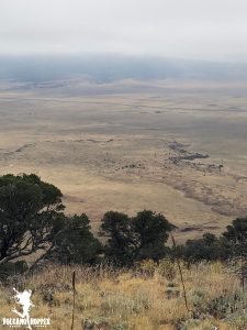
There is an amazing 360-degree view of the surrounding plains from up here. To the northwest, you can spy Colorado’s East Spanish Peak and Johnson Mesa. To the east, you can see Black Mesa in Oklahoma. Baby Capulin – a much smaller cinder cone – pops out of the prairie nearby. Ten miles to the Southeast is the towering Sierra Grande shield volcano – the largest volcano in the volcanic field. Numerous other volcanoes dot the landscape as far as the eye can see.
Trees bravely cling to the cinder cone’s steep edges and, in places, are so thick you can’t see the drop into the crater. The huge flow of lava from the crater’s vent reaches all the way up to the crater rim, and lava bombs can be found scattered everywhere. Plants have taken root in cracks in the lava, and amazingly grow straight up out of boulders.
As we came down around the southern side of the volcano’s rim, we looked down to the plains below and spotted an amazing feature. Remember the lava flow that we had hiked through earlier? From here, we had a bird’s eye view of Capulin’s lava flows and the pressure ridges hidden throughout.
Pressure ridges form in a lava flow when the lava at the leading edge of the flow hardens, but the lava behind it is still fluid. The fluid lava pushes forward and will do one of two things:
- It will dislocate the hardened lava in front of it, pushing it up into ridges (like when you’re shoveling your driveway after a snowstorm and you push it all onto the side of the drive).
- It will run right up and over the hardened lava. The lava piles up on itself, creating these mounds and ridges.
It’s amazing how massive these lava flows really are. Hiking through one of them earlier in the day gave me an appreciation for how thick the formations were, and how large each of these ridges really was. Seeing them from this vantage point made me appreciate their scale, and how far down the landscape they ran. Some of these flows were several miles long and hundreds of feet deep. Impressive!
Seeing the flows from this height makes me want to go explore another lava flow trail: The Boca Trail. This trail wanders past the separate vent that spewed these lava flows onto the prairie floor, leaving Capulin’s magnificent cone intact. And I’m itching to find out what secrets it holds.
Check out our Facebook page for more pictures and some exclusive videos from our hike into the summit crater and around Capulin’s rim!
Up Next: Join us on an adventure through Capulin’s Boca Trail!
Copyright © 2018 Volcano Hopper. All rights reserved.
Some really interesting points you have written.Helped me a lot, just what I was looking for : D.
Great! Glad it was helpful!
I enjoy the report