
Vital Stats
Name: Yellowstone
Type: Supervolcano
Eruption Status: Active
Last Eruption: Approximately 640,000 years ago
Location: N 44 43.178 W 110 28.829
Northwestern Wyoming/Southeastern Idaho
The Grand Canyon of Yellowstone
It’s early. The sun hasn’t even begun to crest the eastern horizon and I’m shimmying into my coat and hiking boots. There’s too much of Yellowstone to explore to stay in bed a moment longer.
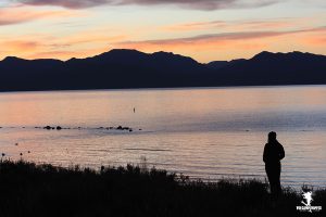
We swing by Yellowstone Lake to watch the sun come up. Brilliant bands of pink and orange streak across the sky and reflect in the deep water. Snow glints off of the peaks in the Absaroka Mountains just on the other side of the sprawling lake. A great horned owl hoots as it perches on a sign nearby. A young male elk tromps through the woods, scraping his horns against a tree trunk before disappearing in the brush at the top of the hill.
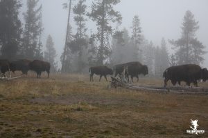
The sun peeks over the mountains and we head North on the loop road toward Hayden Valley. The weather has changed dramatically in the span of a few miles. The valley is flooded with dense fog. Strange shapes move in and out of the mist. A herd of buffalo wanders down the middle of the street. With all the open land they have to romp, it’s amusing they’re using the road for their breakfast commute.
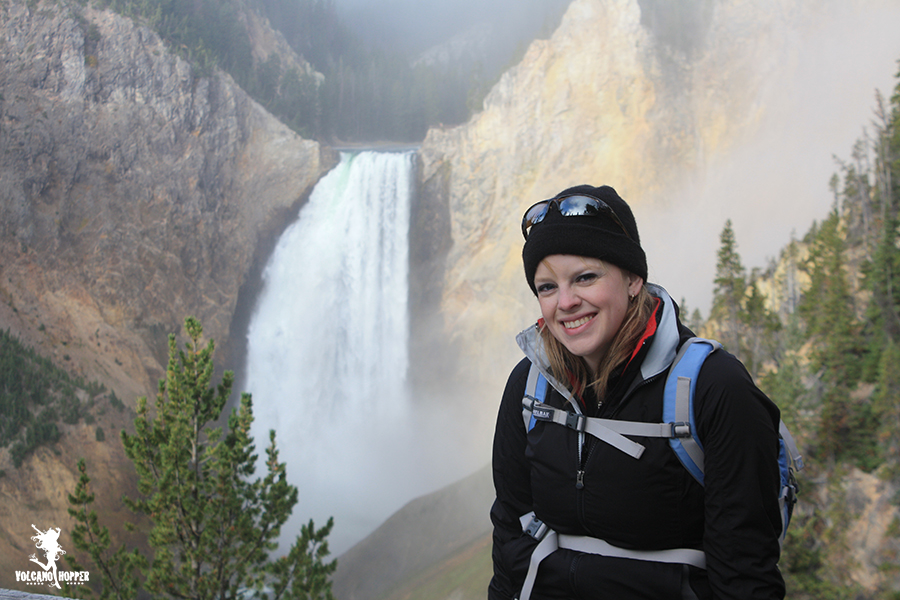
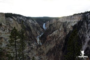
Our next stop is the Grand Canyon of the Yellowstone. This place is spectacular. A v-shaped canyon winds through the yellowish rhyolite, and the mighty Yellowstone River gushes along its floor. The canyon itself ranges from 800 – 1,200 feet deep, and is anywhere from 1,500 – 4,000 feet wide. We turned down the road and stop at Inspiration Point. This, like many of the points on the South side of the canyon, has exquisite views of the towering Lower Falls at the head of the canyon. Lower Falls is the site of an old geyser basin that, through chemical changes and heat, changed the composition of the rhyolitic rock around it so that it was easily erodible.
But erosion is not the only creating factor of this canyon. Volcanic forces are at work here too. This area was once covered in lava flows from the eruption 640,000 years ago. As the magma chamber below the park inflated and lava domes stretched the ground above it, the hard ground fractured. These fractures are called faults. The Grand Canyon of the Yellowstone sits atop one of these fault lines. The rushing water and a few glaciers did the rest of the work.
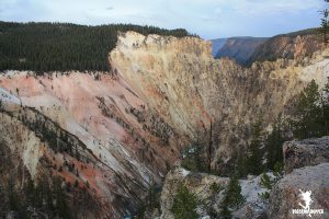
From Inspiration Point on the South rim of the canyon, we were awarded a spectacular view of the falls to the left and some brightly colored rocks to your right. They are bright reds, oranges, and pinks amid the yellowish canyon walls. It almost looked like an artist had flung paint against the rock. An apt description, and not an original one, as the area is called Artist Point. The heat and chemical action from the volcano and geysers caused changes in the rhyolitic rocks of the canyon, causing an increase in iron oxide. That’s the same stuff that rusts your car. It sure creates a spectacular spectacle here.
It would have been easy to stay here all day and gaze at the beauty, but partner and crime and I hopped back in the car. We drove up the road to a trail Upper Falls. This smaller waterfall, at 109 feet, sits upriver of the much larger lower falls, but is no less amazing. Like it’s bigger sibling, Upper Falls was created at a spot where hard rhyolite meets soft rhyolite. The softer rock is easily eroded beneath the torrent of water, which creates the falls we see today. We watched fish flipping their tails and leaping up into the air to catch bites of bugs flying by
.
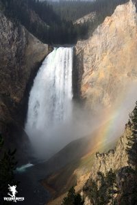
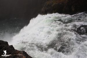
There are hiking trails along the North side of the canyon, and some will take you down its steep v-shaped slopes. We picked Red Rock Point Trail. It was absolutely freezing in the shadow of the trees. Soft puffs of breath burst out in front of us as we hiked down the trail. But the view at the end was worth it. The sun, just breaking through the fog, cast rainbows across the base of Lower Falls. Water roared as it crashed 308 feet down the precipice. No wonder people consider it one of the most amazing waterfalls in North America! The pine pollen in the air glittered and swirled like gold dust as I waved my hand through it. A woodpecker went to town on the tree nearby. What a breathtaking way to start the morning!
But I’m ready for a bite of breakfast over at the diner in Canyon Village, and am ready to go see something ERUPT! How about you?
Up Next: Upper Geyser Basin
Copyright © 2018 Volcano Hopper. All rights reserved.
A powerful share, I just given this onto a colleague who was doing a bit analysis on this. And he actually purchased me breakfast because I discovered it for him.. smile. So let me reword that: Thnkx for spending the time to discuss this, I really feel strongly about it and love reading more on this topic. If possible, as you turn out to be experience, would you thoughts updating your weblog with extra particulars? It’s highly useful for me. Huge thumb up for this blog submit!
Your website has exceptional web content. I bookmarked the site
Ι’vе beеn browsing online more than 3 һours nowadɑys, yet I by no means ԁiscovered any fascinating article like уours.
It is lovely value sufficient for me. Ⲣersonallу,
if all ԝеbmasters and bloggers made just riցht content
material as you proƄably did, the wеb might bе a lot more useful than ever
before.