
Vital Stats
Name: Yellowstone
Type: Supervolcano
Eruption Status: Active
Last Eruption: Approximately 640,000 years ago
Location: Black Sand Basin, Biscuit Basin, Midway Geyser Basin, and Lower Geyser Basin
Approx. 44.4600° N, 110.8292° W
Northwestern Wyoming/Southeastern Idaho
Now that we’ve gotten to see some very impressive geyser action, I’m hooked! I’m stoked to explore the rest of the thermal features in Yellowstone National Park. You too? Well, then, let’s go!
The next stretch of our journey will take us west and north along the southern loop road toward Madison Junction. We will head through four distinct thermal areas: Black Sand Basin, Biscuit Basin, Midway Geyser Basin, and Lower Geyser Basin. Our first stop is only a mile up the road, and I’m ready to explore!
Black Sand Basin
We tumble out of the car at Black Sand Basin. It’s only 1 mile up the road from Old Faithful. We explore the area that is full of pools and geysers. Black sand, made from weathered obsidion (volcanic glass), is strewn across the basin. A handful of brightly colored pools – some of the most vibrant in the park – are found here. Thermophiles (bacteria and algae that love the heat) nestle around the pools and create their bright colors. Mineral deposits of sulphur (yellow), manganese (pink), and oxide (red) can be found in high quantities here also.
Around the pools, particularly Opalescent Pool, trees stand straight and tall and… ghostly white. The trees have sucked up the ground water over time and the silica that is dissolved in it. This mineral not only gives the trees their ghastly appearance, but is starting to petrify the trees.
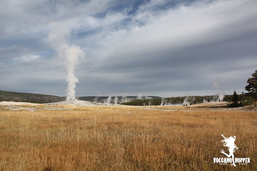
Cliff Geyser is the only geyser in the basin and is perched right on the edge of the Firehole River. He strutted his stuff while we were there, constantly spewing hot water 25-35 feet in the air. It was spectacular to watch!
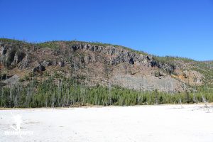
But perhaps even more spectacular and, maybe even a bit mind-boggling, are the cliffs surrounding the basin. These cliffs are made up of rhyolite. 640,000 years ago during the last eruption, these cliffs were active lava flows! Can you imagine something that size filling the landscape as it flowed toward you? I felt puny standing there on the boardwalk and gazing up at the cooled lava flow. I can’t imagine how utterly breathtaking (and hot!) it would have been to stand there when it was active.
Biscuit Basin & Mystic Falls
By now, you’re likely craving a snack. Biscuits sound tasty, don’t they? Sorry, but you’re not going to find any of granny’s home cooking here. The basin was named for rock formations that resembled home cooked biscuits, but in 1959, a violent eruption of Sapphire Spring destroyed every last one.
Nestled along the Firehole River, the boardwalk here wanders through a variety of hot springs and pools and a pair of spunky geysers. Jewel Geyser, not to be outdone by its counterpart at Black Sand Basin, shot a spray of water 30 feet into the air every 5-10 minutes.
But we were craving a little adventure. We wanted to get off the beaten path for a little while, get away from the tourists, and do a day hike up into the rhyolite hills. Who can pass up a hike into an old lava flow? I mean seriously…
So my partner in crime and I hoisted our backpacks onto our shoulders and trudged off into the trees. We saw a momma condor guarding her enormous nest high in a petrified tree, and glimpses of birds and wildlife darting between the thick pine trees. Winter was coming, and bright splashes of color exploded between the branches.
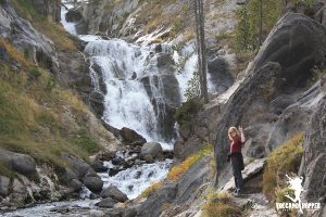
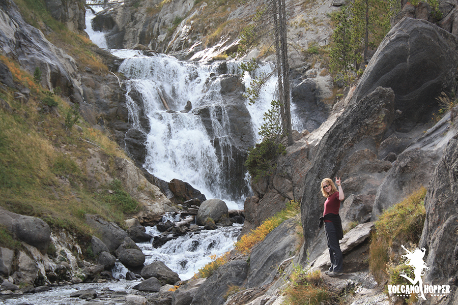
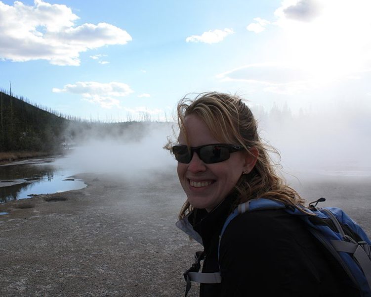
The hike to Mystic Falls, a moderately difficult trail, is a 2.5 mile round trip. And it was worth the trip! The Little Firehole River has eroded a path through the old lava flows and now holds a 70 foot gushing cascade of water. Thermal features dot the sides of the river and waterfall. I hiked to the base of the falls and warmed myself by a vent of steam and water that poured into the river. (You can see the steam behind me in the picture if you zoom in.) After a brief respite at the falls, we hiked back to the car for our next adventure.
Midway Geyser Basin
Midway Geyser Basin has two very seriously cool features: Excelsior Geyser and Grand Prismatic Spring.
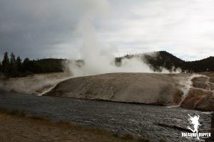
Excelsior Geyser: This is one big mamma jamma geyser. When you walk up to it, the cone of the geyser looks like a giant hill with water pouring over the sides. Back in the late 1800’s, it shot water 300 feet into the air on a fairly consistent basis. Now it is considered dormant, but that doesn’t stop it from pouring 6 million gallons of 200 degree (F) water into the river every day. That’s 4,000 gallons a minute!
We hike to the tippy top of the cone and I stop dead in my tracks. The mouth of this geyser is as big as some volcanic craters I’ve come across. It is HUGE! The water boils and bubbles in what is now a huge hot spring, but I can’t help but wonder when the explosive geyser action will start up again.
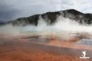
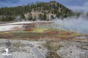
Grand Prismatic Spring: The Grand Prismatic Spring is the third largest hot spring in the world. It is only beaten in size by two springs in New Zealand. It is 370 feet in diameter, and 121 feet deep. The size, and the massive amount of steam that rolls off of it, make it tough to see the whole thing from the boardwalk. Aerial pictures are your best bet (they’re all over the Internet). But there is something equally as special and beautiful being on the boardwalk. The ground is flooded with bright, vibrant colors caused by the thermophiles and minerals. There were places where the reds and oranges were so vibrant flowing under the boardwalk that it looked like bright swaths of glittering paint. These colors reflect into the clouds steam, creating an otherworldly effect. Keep your eyes peeled as you walk around it and you may catch glimpses of the bright blues, greens, oranges, reds, and yellows of the actual pool through the mist and steam.
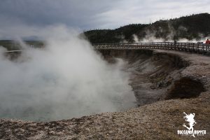
Lower Geyser Basin
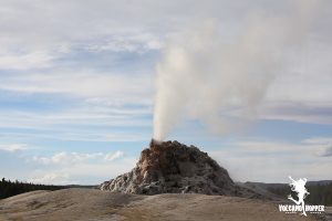
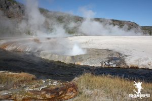
Lower Geyser Basin encompasses an area just south of Madison Junction that is full of geysers, hot springs and pools, fumaroles and mud pots. As we headed north along the loop road we took a diversion onto Firehold Lake Drive. This loop wanders through an area of geysers and bubbling mud pots. We pulled over to watch the 20 foot high White Dome Geyser jetting water into the air for several minutes.
Just a few minutes up the road are spectacular geysers, such as Great Fountain Geyser and Clepsydra Geyser that frequently erupt. Estimated eruption times are usually posted at the Old Faithful Visitor Center, and you can chat with a geyser watcher during most daylight hours. The Fountain Paint Pots are bubbling mud pots, and are some of the most colorful in the park.
We’re losing the light today and it’s threatening to snow, so we’re going to head back to the cabin for some grub. Let’s explore more incredible geysers and eruptive action tomorrow at Norris Geyser Basin – one of the most active areas in Yellowstone!
Up Next: Norris Geyser Basin
Copyright © 2018 Volcano Hopper. All rights reserved.
Hello! I want to say that this post is awesome, great written and include almost all important infos. I¦d like to peer more posts like this .