
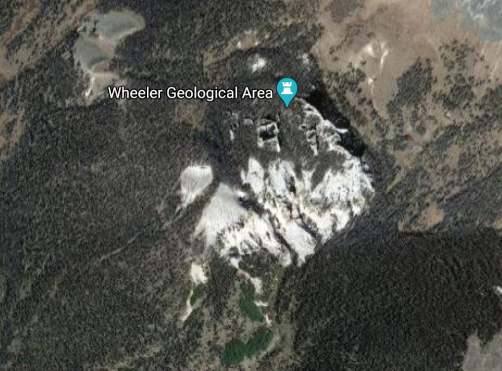
Wheeler Geologic Area was created from the fallout of Earth’s largest explosive eruption. When La Garita Caldera exploded millennia ago, it deposited 1,200 cubic meters of volcanic material throughout the state of Colorado. The Fish Canyon Tuff, as it has come to be known, can most easily be seen here at Wheeler Geologic Area. Nestled deep in Colorado’s San Juan Mountains, the tuff here has been well preserved over the years due to the surrounding valley. Wind and water have weathered the tuff over time, sculpting a dramatic landscape of spires.
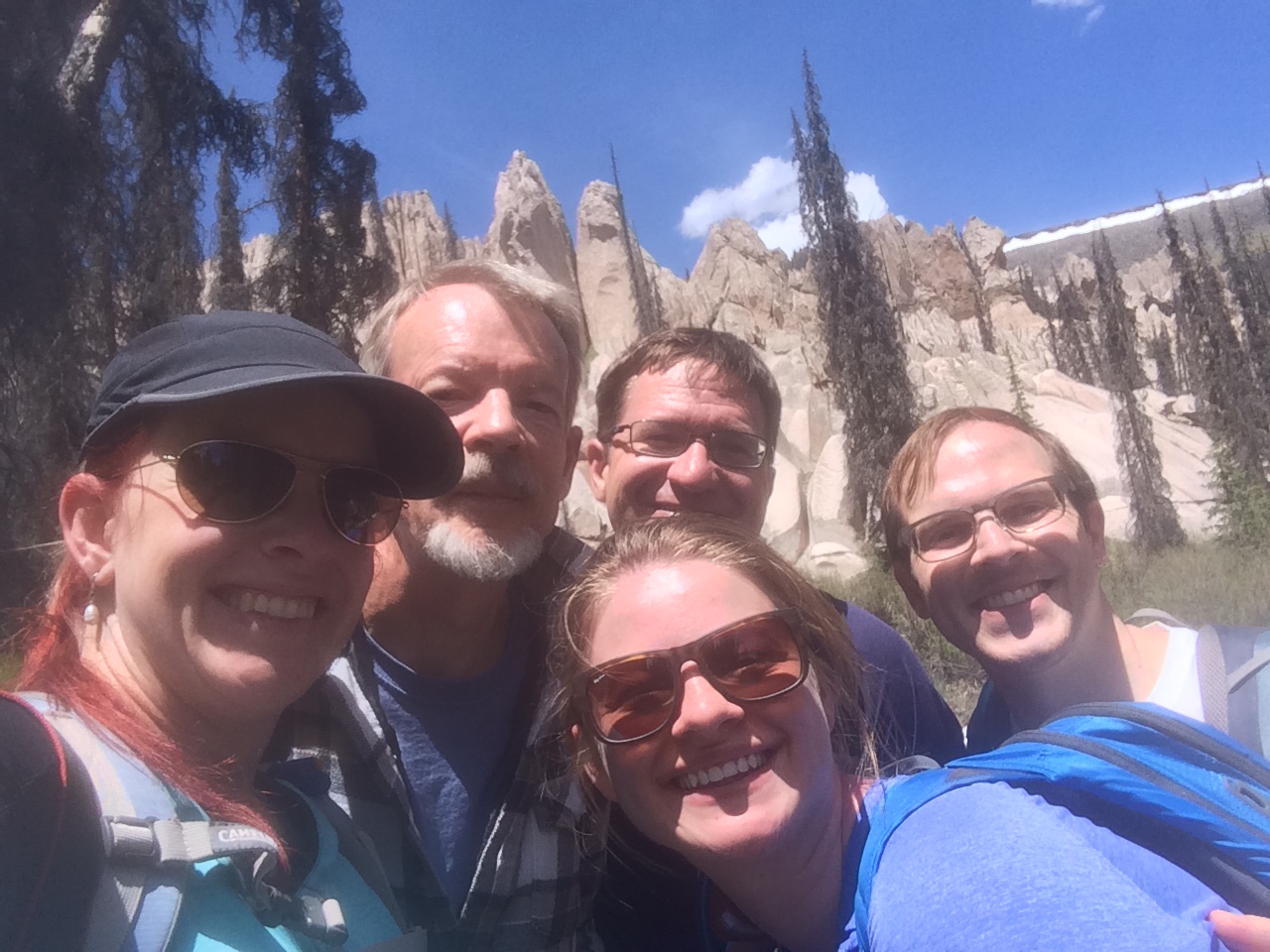
Not very many visitors brave the 14-mile service road or 16-mile hike through the volcanic landscape. We not only love to explore volcanoes, but we love to discover the side of them that many people don’t get to see. Five of us began our hike at dawn from Hanson’s Mill, through thick forest and over age-old lava flows. (Catch up on the first part of our adventure here.) With the first stretch of our journey under our belts, we set off to explore the tuff formations at Wheeler Geologic Area.
Dragon’s Eggs
The trail rose steeply as we entered the 640-acre geologic area. Eroded tuff and ash covered the trail. It making it as slippery as a sand dune in places. Forest and foliage had taken root in the ashy soil and pines towered high above our heads. A creek bubbled across the trail and we hopped it, heading deeper into the monument.
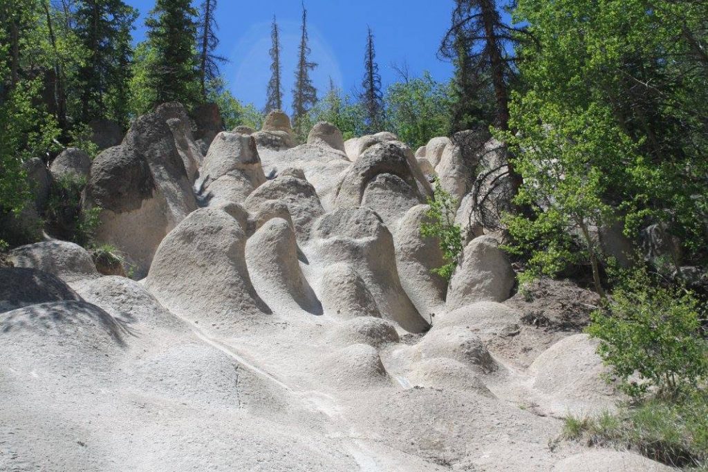
The forest suddenly fell away to our left and revealed a huge swath of gray tuff on the hillside. It towered a couple hundred feet above us. The tuff here had eroded over the years, leaving behind formations that are called hoodoos. The patch of hoodoos here in the forest clustered together like a nest oblong dragon eggs. I could certainly imagine a dragon here among the rock formations and forests, relentlessly guarding her nest.
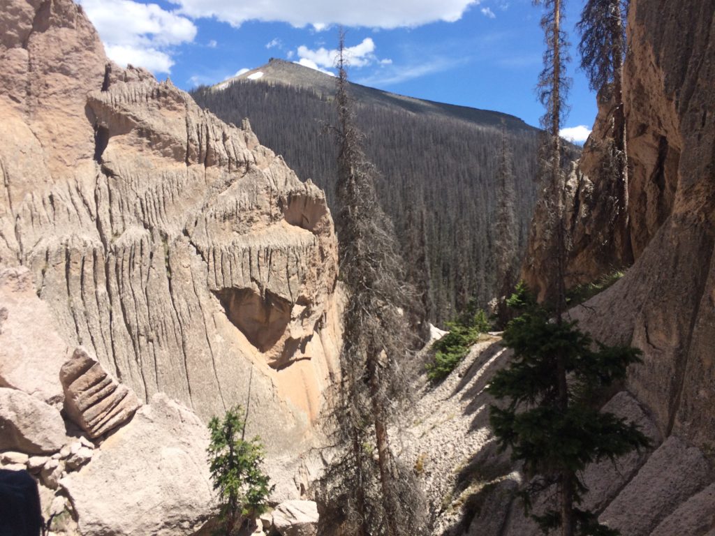
We continued on down the trail toward the main formations of Fish Canyon Tuff. The formations filled the valley ahead of us and their sheer size was daunting. Photos don’t do it justice. The formations are hundreds of feet high and the spires seem to scrape the sky as you stand under them. Wheeler’s Fish Canyon Tuff is so large that it is visible in satellite images as a white streak in the forest. But what is tuff anyway?
Fish Canyon Tuff
Tuff is rock that is made from layers of volcanic ash. When a volcanic eruption happens, ash is launched thousands of feet into the atmosphere. When it falls, it can collect in thick, heavy layers. The layers compress under their own weight. Add moisture that may have been released during the eruption or a water source and the ash turns into something similar to wet concrete. (One reason why you never want to breathe ash.) When the ash finally hardens, voila! You have tuff.
We spotted countless holes and empty pockets in the tuff where trapped gas had once escaped. This makes the rock fairly light, compared to other rocks like granite. Small rock and lava particles were trapped in the layers of tuff – all erupted by La Garita.
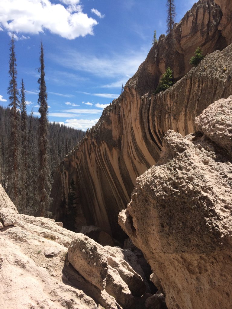
The tuff is banded with different colored layers, making it look like beautiful tiger stripes in the rock face. The layers are also oxidizing at different rates. This suggests that the chemical compositions of ash and lava changed over the course of La Garita’s eruption. Perhaps as the hours and days went by, it tapped into different fuel sources or the strength of the eruption strengthened and waned. Geologists are still studying the eruption that happened here and continue to form theories about how the Earth’s largest eruption played out.
A Tuff Climb: Into the Heart of Wheeler Geologic Area
From a distance, the Fish Canyon Tuff at La Garita looks like bunched up fabric. As we approached the base of the formation, we discovered deep chasms and crevices in the cream colored tuff. Snow lingered in the deepest cracks, even in July.
At the south end of the formation, the trail forks in two directions. One leads sharply uphill to the top of the formation, awarding fantastic views from the top. The other leads along the base of the formation and winds up into the heart of the tuff.
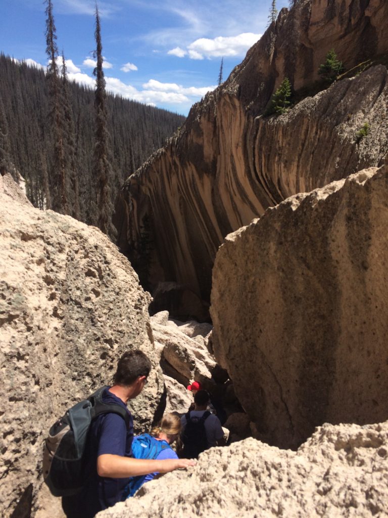
The Lower Trail
We only had time to choose one path that afternoon. We chose the road less traveled along the base of the tuff. The spires stretched high above our heads, absolutely dwarfing us as we hiked. As the trail gets fainter, it turns and winds over a creek and up a chasm in the rock. We admired the tiger-striped layers of tuff and examined the chunks of rock around us. In some areas, it looked like that same dragon that was guarding her eggs had taken her huge claws to the rock. Some would say that dragons don’t exist, but as we climbed through this remote wilderness, I wasn’t so sure. Did dragons use tuff as a scratching post? I could only wonder as we eyed the eroded gouges in the rock.
We climbed until we could go no further. The five of us basked in the warm summer sun as we took in the fact that we were exploring fallout from the largest eruption in our planet’s history. As massive as this tuff formation was, it wasn’t even a fraction of what La Garita had erupted.
The La Garita eruption ejected 1,200 cubic meters of material. Volcanologists have suggested adding a tenth level to the VEI scale to accommodate the volume of material that this eruption produced. La Garita is the only known volcano to have ever produced such a quantity of material. The amount is almost inconceivable.
The Trail Home
Knowing that we still had 8 miles back to the trailhead, we skipped the trail that led to the top of the Fish Canyon Tuff formation. It gives us something to come back and explore next time! Wheeler Geologic Area is definitely a place that I would love to visit again.
The climb back out of the valley was incredibly steep – almost as steep as Mount St. Helens’ Monitor Ridge. We veered off the muddy service road and trekked back across the alpine plateau. Heading down through the old lava flows and domes, we chatted and laughed about what we had just seen. We had just enough cell phone service to get exactly one text – that a best friend’s baby had just been born! What happy news to fuel the hike.
We reached the river and splashed headlong through the shallowest part. We were starting to feel the effects from being in high altitude, intense sunshine, and heat all day. Stopping for a few minutes, we fueled up on water and snacks. A few sport jellybeans really put a spring in our step as we climbed the switchbacks on the east side of the river. As we crossed the ancient basalt flows and headed into the forest again, the light had started to fade. We started to wonder about cougars and bears, giving a shout every now and again to warn them of our presence.
My brother and I struck up a silly song we had learned from our grandparents when we were kids. The five of us told stories to make that last mile seem shorter. Then, just as the sun was approaching the western horizon, we broke out onto the trailhead at Hanson’s Mill.
See Ya, Wheeler!
Tumbling into the car, we drove down the dusty road until we found the highway again. We had felt the tiredness creeping in as we hiked, but once we sat down, full on exhaustion hit. And we were hungry. Maybe even a little hangry.
We stopped at a place called Three Barrel Brewing in Del Norte, Colorado. They had hot pizza and ice-cold beer. Wood fired pizza is my absolute favorite and after that hike, and none had ever tasted better. Kicking back and enjoying dinner with some of my favorite people while sharing the best memories from the day was a great way to end such an adventure.
Copyright © 2020 Volcano Hopper. All rights reserved.
Loved this post? Share it!